Evaluation of Google Fusion Tables
Google Fusion Tables is a simple and fast method of creating an online map that links to your digital collections. Depending on the set up of your digital collection and your infrastructure, you may want to consider using Google Fusion Tables. To help you with your decision, we have created a PDF fact sheet: [Google Fusion Evaluation] that highlights different aspects of the service: technical support, data management, intellectual control of information, and display of information.
Observed Limitations
While we were testing Google Fusion, we discovered a few limitations. This may be due to the fact that Google Fusion is still an experimental/beta service. As of January 28th, 2013, these limitations were present:
1. Google Fusion maps cannot display two records at the same geographic location.
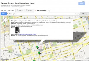
In our sample data, there are two separate records for 199 Yonge Street. In Google Fusion Table map, there is only one map marker at 199 Yonge Street. This is the same case when it is embedded on a website.
Workaround: You can modify the location data the location data, so that you would have two separate geographic locations for 199 Yonge street. This can be done by moving the marker in Google Fusion or determining the latitude/longitude coordinates or assigning an dummy address to a nearby location.
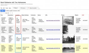
Example of how to adjust the locations by address and geographic coordinates.
2. Customized symbols and boxes do not convert “as is” into KML. Workaround: Modify the KML file directly in Google Earth, and save it in Google Earth.
3. Content Management Systems such as WordPress and Drupal may requireplug-ins to be installed so that Google Fusion code can be displayed. Workaround: In WordPress, enable the Unfiltered MU plug-in.